مطالعات خلیج فارس
ایران را بشناسید تا ایران را بیشتر دوست بداریدمطالعات خلیج فارس
ایران را بشناسید تا ایران را بیشتر دوست بداریددرباره من
 M.A Iranology
Shahid Beheshti University
Mohsenpour Hamidreza
ادامه...
M.A Iranology
Shahid Beheshti University
Mohsenpour Hamidreza
ادامه...
The Indian Ocean in Eurasian and African World-Systems before th
The Indian Ocean in Eurasian and African World-Systems before the Sixteenth Century*
PHILIPPE BEAUJARD
Centre
National de la Recherche Scientifique, Centre d'Études Africaines,
École des Hautes Études en Sciences Sociales, Paris, France
|
||||
| Writing of the Mediterranean, Fernand Braudel has remarked, "It isn't water that links its shores," but "seafaring peoples." From a very early date, the Indian Ocean, too, was traversed by sailors, traders, religious men, and migrants moving in search of goods, new lands, or the great unknown. Their movements were shaped by numerous factors, both geographic and social in origin. Over the centuries, these exchanges transformed the Indian Ocean into a unified space.1 Trade —above all, long-distance trade—played a central role in this process. A study of the history of trade networks, together with political and religious factors, allows us to understand the creation of particular societies, as well as the larger area to which they were linked. | 1 | |||
| Trade implies not only an exchange of goods, but also an exchange of knowledge, beliefs, and values. The power of trade to unify, create, and transform cultures can be appreciated only by viewing it from the widest possible angle. The Indian Ocean, our case in point, became a unified space through exchange networks that went far beyond its own borders, reaching from China to Europe and Africa. Gradually over time, transcontinental networks—both maritime and terrestrial—linked the Indian Ocean to the Mediterranean, turning it into a unified zone wherein events and developments occurred interdependently. Therefore, the Indian Ocean should not be considered as a discrete case that underwent processes similar to those of the Mediterranean, as K. Chaudhuri has suggested, but rather as an area that was integrally tied to the Mediterranean. The fact that the different regions of the ancient world united by trade experienced a demonstrable synchronization in their development suggests (but is not yet sufficient proof for) the systemic nature of their relations. | 2 | |||
It is not only the interconnections or the size of the networks but
the regularity, intensity, and speed of the exchanges that resulted in
the different regions being progressively integrated and shaped into a
world-system. This notion was originally conceived by I. Wallerstein in
1974, in a holistic perspective that "looks for an explanation at the
level of the whole." This perspective, which E. Morin has rightly
pointed out the limits of, has not clearly defined the concept of
"system" itself. Before proceeding with the discussion, I should
identify what I mean by the term "system." I follow the definitions
established by Morin, namely, (1) a system represents a "complex unit and the complex of relations between the whole and its parts," (2) a system is made up of cumulative interactions, (3) which constitute the organization of the system.2
The character of this organization is, in essence, both complex and
dynamic. The system generates both order and disorder, unity and
diversity. Taking into account these general characteristics of all
systems and their implications can aid the interpretation of the
available historical data for the Eurasian and African zone. The
systemic approach provides a new "logic," and leads to a new
understanding of world history http://www.historycooperative.org/cgi-bin/justtop.cgi?act=justtop&url=http://www.historycooperative.org/journals/jwh/16.4/beaujard.html | ||||

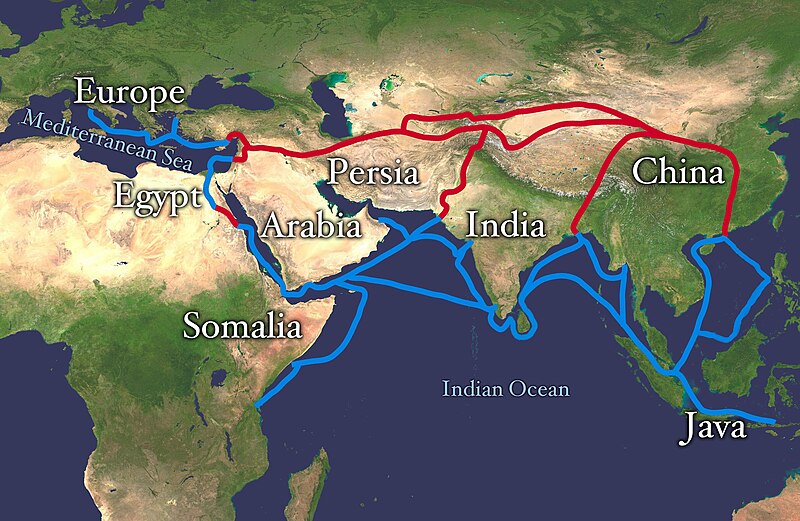
The Spice Route
The Spice Route was the other great trading route of the Ancient and
Medieval worlds. Spices were carried on the Silk Road also, but the
main source of spices was well south of China, the Spice Islands
(Indonesia), India, and the Malabar (East African) coast. India was at
the center of the world spice trade. It is no accident that Indian food
is known for its spices. Spices were carried to India from the Spice
Islands, sometimes by sea routes. Spices included cassia, star anise,
cloves, coriander, nutmeg, mace, and others. The most vluable spice was
pepercorns. These spices as well as Indian Indian and Africa spices
were then brought by sea to the Middle east by Areab traders. Finally
Venetian or other Italian vessels were bring the spices to Europe.
Rivalry for the sea routes monopolized by Venice increased the
importance of the overland Silk Road. Finally Portuguese sailors in the
15th century established direct contact with the source of spices,
undercutting both the Arabs and Venetians.
Spices
Spices included cardamom, cassia, cinnamon, cloves, coriander,
ginger, mace, nutmeg, star anise, turmeric, and others. The most
vluable spice was pepercorns from the Malabar Coast (south-western
Indian coast) were dried and ground into powdered pepper.
Modern readers often do not appreciate the impotance of spices in the
Ancient and Medieval worlds. It must be understood that food was
usually not very palitable. Not only were there few ways of preserving
foods. Vegetables were unavailable in the Winter and early Spring.
There was no way of storing large quanties of cattle fodder. Thus the
only beef available was salt beef. Even during the Summer meat was
often unpalitable because of the lack of refrigeration to poperly store
it. Many common modern foods were unavailbe to Europeans, including
potatos, corn, tea, coffee, chocolate, bananas, tomatos, oranges,
lemmons, and other foods. Most strikingly, there was no sugar to
sweeten foods, except honey. Thus spices were in great demand to flavor
foods. And modern culinary trends show the imprint. Nutmeg is used in
Italian cooking. Iranian (Persian) cooking has cinnanon-scented
sauces. Steak tartare became popular in Germany. There are gungerm
cloves, and sweet-and-sour touches in Alsatian cooking.
Ancient World
Spices were a valuable trading commodity in antiquity. This means
there were established trading routes in antiquity. Pepercorns were
found in the nose of the mummy of Ramses II. Peper and other spices
were valued commodities in Roman markets. The European trade in these
commodities fell with the economic decline following the fall of Rome
(5th century AD). Another factor was the rise of Islam (7th century
AD). [Turner]
Trading Route
The Spice Route was the other great trading route of the Ancient and
Medieval worlds. Spices were carried on the Silk Road also, but the
main source of spices was well south of China, the Spice Islands
(Indonesia), India, and the Malabar (East African) coast. India was at
the center of the world spice trade. It is no accident that Indian food
is known for its spices. Spices were carried to India from the Spice
Islands by sea routes. The spices as well as Indian Indian and Africa
spices were then brought by sea to the Middle east by Arab traders. The
Arabd purchased spices from the Indians and from Chinese and Javanese
merchants who sailed to Indian ports. Finally Venetian or other Italian
vessels were bring the spices to Europe.
Arabs
The Arabs burst out of the Arabian Desert in the 7th century. The
Arabs cut Europe off from the clove islands. They became the masters of
the spice trade. The Arabs dominated the trade routes from India and
eastern Africa. They kept the sources of spices secret from the
Europeans. The Arabs told fantastic tales of the dangers they faced in
obtaining spices in distant and mysterious lands. Spice trading was
important to Arabs from the very beginning of Islam. Mohammed
(570-???AD) himself married into a spice-trading family when he chose a
wealthy widow. Islamic armies as they moved throughout the Middle East
gained comtrol over the trade routes to Europe as well as in some cases
the very sources of the pices them selves. (Much of the Spice Islands
were conquered by the Arabs, the Islamic Monguls conquered India, and
the Arabs established themselves in Zanzibar and elsewhere in East
Africa).
Italian Trading States
Te European taste for spice began to revive in the 9th century. A
factor here was the rise of the great Italian trading states like Venice
and Genoa. [Turner] The trade was at first limited. Feudal Europe
still gebnerated still limited wealth. The growth of cities and the
rise of the merchant class was just beginning. Arab controlof te trade
roots made spices enormously expensive.
Crusades
Disease
It is believed that the Spice Route is how the bubonic plague reached
Europe. The medieval plague, commonly referred to as the Black Death,
was the most cathestrophic epidemic in recorded history. The plague is
believed to have been brought west from China. Europeans had no
resistance to it in much the same way that smallpox brought by Europeans
was to desimate Native Americans in the 16th and 17th centuries. The
plague ravaged Europe from 1347-51. There were also serious subsequent
outbreaks as well. The plague often killed whole families, in part
because family members could not bring themselve to abandon each other.
Villages were devistated. An estimated 1,000 villages were completely
destroyed. Historians estimate that about one-third of the European
population died in the plague. The plague, however, had a profound
impact on Europe beyond the incalcuable human pain and suffering of
those affected. As strange as it may sound, the plague set in motion
cultural and economic trends that played a major role in shaping modern
Europe.
Venetians
Silk Road
The other great international trading route was the Silk Road. Some
spices were carried on the Silk Road, but much greater quantities were
transported by the Spice Route. The history of the famed Silk Road is
one of many instances in which clothing and fabrics have
played a major role in human history. The story of the silk road is one
of military adventures and conquest, adventuresome explorers, religious
pilgrims, and great philosophers. While it is silk which is often,
naturally enough, most strongly associated with the silk road, the flow
of ideas and religion as an almost unintended aspect of the flow of
trade may have been one of the most significant impacts. Of course most
of the people who traversed the silk road were not great thinkers, but
common tradesmen who transported their merchandise at great risk for the
substantial profits that could be made. They moved cammal caravans over
some of the most hostile terraine on the planet. The ilk road
tranversed deserts, mountains and the seemingly endless Central Asian
steppe. Some of the great figures of history are associated with the
Silk Road, including Alexander the Great, Marco Polo, Genghis Khan, and
Tamerlane. Merchandice may have moved over the Silk Road as early as the
5th century BC. The Silk Road is believed to have become an
established trade route by the 1st century BC and continued to be
important until the 16th century when more reliable sea routes were
established as a result of the
European voyages of discovery.
Marco Polo
Marco Polo traveled to China on the Silk Road, but his account of
his journey included the first factual information available to
Europeans about the actual source of the spices obtained from the Arabs.
He described hot lands where he saw spices growing. He also explained
the key role of India.
Rivalry
Rivalry for the sea routes monopolized by Veniceincreased the importance of the overland Silk Road.
Fall of Byzantium
The Ottomans with the fall of Byzantium gained control of the Black
Sea. They gradually displaced the Venetians in the northern Aegean.
Expansion south into Syria and Egypt further closed lucrative trade
routes to European shipping. The control of territory from the Russian
steppe to Egypt allowed the Ottomons to interdict established European
trade routes to the East. It was this Ottoman control of the spice trade
routes that was a factor in pushing the European voyages of discovery.
European Voyages of Discovery
The account of Marco Polo with actual descriptions of China and the
Spice Islands fueled a desire by Eurpdeans to establish direct trading
links. At the same time Europeans by the 14th century had significantly
imroved their navigational and ship building skills. The astrolabe
helped mariners determine latitude. (Longitude proved a much more
difficult undertaking. The magnetic compass permitted mariners to
determine which direction was north. Great improvements were made in
maps. Here Portuguese cartographers played a key role. Information
provided by travelers was refined by explorers who began to sail south
along the African coast. Europeans also made great strides in
shipbuilding. Large capacity ships called galleons were adopted.
Powered by sail and woth large holds, they greatly reduce the cost of
transporting good over distances. These developments permitted
Europeans them to begin to make voyages od substantial distances and the
goal was to reach the East to develop direct trade contacts with China.
Many of the advances were made by the Itlalian mariners of the eastern
Mediterranean. It was, however, the western European countries of the
Atlantic that would conduct the great voyages of discovery. Finally
Portuguese sailors in the 15th century established direct contact with
the source of spices, undercutting both the Arabs and Venetians. One of
te great disappointments with Columbus and other explorers sailing west
was the failure to find cloves, nutmegs, and other spices. [Turner]
Sources


اطلس های خلیج فارس
http://fa.wikipedia.org
تا کنون چندین اطلس در بر دارنده نام و نقشههای خلیج فارس منتشر شده و مشخص می کند که نام خلیج فارس در همه نقشه های کهن بکار رفته در کتاب:اسناد نام خلیج فارس، میراثی کهن و جاودان, جزئیات کامل این اطلسها در گفتار ۱۱ صص ۹۸-۱۲۲ "مبحث اطلسها"[۳] نقد و برسی شدهاست چند نمونه از آنها عبارتنداز:
- اطلس تصویری تونس ۲۵۳ نقشه چاپ موسسه جهانی عرب پاریس و دانشگاه تونس ۲۰۰۱
Atlas of The Arabian Peninsula in Old European Maps (253 maps) by Khaled Al Ankary, Institute du Monde Arabe,Paris and Tunisia University,2001 تقریبا تمام نقشهها نام خلیج فارس و معادلهای آن را دارند اولین نقشه این اطلس،تصویری از یک نقشهٔ طراحی شده بر روی چوب است که توسط فرانشیکو ایتالیایی به سال ۱۴۸۰م. ترسیم شدهاست.مشابه نقشه یهای منسوب به بطلیموس است که خلیج فارس شکل مستطیل است .آخرین نقشهٔ اطلس مذکور(تونس) نقشهٔ شماره ۲۵۳ ویک نقشهٔ رسمی دولت عثمانی متعلق به سال۱۸۹۵ م. است که در آن خلیج فارس را با نام بحر فارس ثبت کرده وکورفزی بصره را نیز آورده.یک نقشهٔ دیگر دوره عثمانی که سال ترسیم آن احتمالاَ ۱۷۲۱ م. است خلیج فارس را بحر فارس و دریای عرب را بحرعجم ثبت کردهاست. در میان نقشههای اطلس مذکور ۱۰ نقشه علاوه بر ثبت نام خلیج فارس در محل خودش(پرشن گلف)،دریای عرب و بحر عمان فعلی را نیز دریای فارس یا پرشن سی ثبت کردهاست از جمله میتوان نقشههای صفحات ۲۲۶-۱۴۱-۳۲۳-۳۲۲-۳۳۱-۳۴۵-۳۴۷-۳۶۳-۳۵۵ و نقشه شکل اسبی بسیار هنری بوتینگ Bunting H.S.Q34/24CM Hanover,1620 دریای فارس(بجای دریای عرب) و خلیج فارس را نام برد. [۴]
- اطلس" نقشههای تاریخی خلیج"چاپ ۱۹۹۶ شارجه
این اطلس در دو جلد چاپ شده که مجموعاً حدود ۵۰۰ نقشه با نام خلیج فارس دارند. این اطلس" نقشههای تاریخی سالهای ۱۴۹۳-۱۹۳۱م. خلیج فارس را که دارای ۲۷۶ نقشه از منابع اروپایی است در بر میگیرد و توسط "سلطان بن محمد القاسمی یکی از مقامات امارات متحده عربی" ابتدادر سال ۱۹۹۶م. به سفارش وی در لندن چاپ و توسط "منشورات مدینه شارقه للخدمات" منتشر شدهاست در این اطلس نیز مانند اطلس تونس ۹۸% نقشهها نام درست خلیج فارس وجود دارد. اطلاعات موجود در نقشههای جهان نما تا ۱۷۰۰ همچنان فراتر از ۷ دریا و ۷ اقلیم نرفته و به سبک قدیم و سبک جغرافیانویسان مسلمان، چین در شرق ، اروس در شمال، فرانکه در اروپا و افریقیه در جنوب لبههای پایانی دنیا و دریای محیط بدور دنیا و کوه قاف حلقه پایانی دنیای سینی شکل است. حدود سال ۱۷۵۳م. نیکلاس دی فر (۱۶۹۴-۱۷۵۴م )اولین بار نقشه جهان را تقریباً به شکل امروزی ترسیم کردهاست.
- اطلس عراق در نقشههای قدیمی
در این اطلس که تألیف "احمد سوسه" پدر کارتوگرافی در عراق است، بر اساس منابع یونانی و اسلامی ۳۹ نقشه به زبان عربی و به طریقه سیاه و سفید ترسیم شدهاست که نام خلیج فارس در همه این نقشهها از جمله در نقشهٔ دوره آشوریان به شماره ۶ ، نقشهٔ هیکاتوس (متوفی ۴۷۵ ق.م.) به شماره ۷ که به امپراتوری فارس و مصر سفر نمودهاست، نقشهٔ ایراتوستین یونانی به شماره ۹ ، نقشهٔ بطلیموس به شماره ۱۰، در واژهٔ خلیج فارس ( سینوس پرسی) به کار رفته و اما در نقشهٔ فتوحات قرن اول هجری به شماره ۱۱، نقشه ی( بلخی ۹۳۴م.) به شماره ۱۲ ، نقشهٔ دیار عرب اسطخری (۹۵۱ م.) به شماره ۱۶ و نقشهٔ عراق از اسطخری به شماره ۱۸ ، نقشهٔ جهان نمای ابن حوقل(۹۷۷م.) به شماره ۱۹ ، نقشهٔ عراق از ابن حوقل به شماره ۲۲، نقشه جهان از جیهانی( ۹۷۷م.) به شماره ۲۶، نقشه جهان نمای ادریسی( ۱۰۹۹-۱۱۶۴ م.) به شماره ۲۹ ، نقشه جهان نمای قزوینی (۱۲۰۳-۱۲۸۳م.) به شماره ۳۱ ، نقشه ابن الوردی ۱۳۴۸م. به شماره ۳۶ نقشه شماره ۳۸ از جغرافیانویس مجهول و نقشه شماره ۳۹ به نام مواضیع التاریخیه کلمهٔ بحر فارس ( دریای فارس) بکار رفتهاست.
- اطلس مذکور توسط موسسه کارتوگرافی سحاب دو بار باز چاپ شدهاست.
- دولت کویت درسال ۱۹۹۲ م. کتابی را مشتمل بر هشتاد نقشه و سند تاریخی تحت عنوان " الکویت فی الخرائط العالم" (کویت در نقشههای جهان) به چاپ رسانیدهاست که در همهٔ این نقشهها و اسناد تاریخی که از اطلسهای مختلف گرد آوری شدهاست، نام خلیج فارس وجود دارد.
- اطلس "الکویت قراءه فی الخرایط التاریخیه" در سال ۱۹۹۴ م. در کویت به همت عبدالله یوسف الغنیم به چاپ رسیده که حاوی حدود 200 نقشه با نام خلیج فارس است.
۶ - اطلس" ریشههای کویت" بنام( اصول الکویت المنشور العام ) که در سال ۱۹۹۱ در هلند به چاپ رسیدهاست،پانزده نقشهٔ تاریخی وجود دارد که در همهٔ آنها نام خلیج فارس ثبت شدهاست.
- بنیاد ایرانشناسی نیزکتاب «وصف خلیج فارس در نقشههای تاریخی، با ۴۰ نقشه اسلامی و ۱۲۰ نقشه اروپایی را منتشر کردهاست.[۵]
- "اطالس التاریخی للعالم الاسلامی فی العصور الوسطی" عبد المنعم ماجد، علی البنا، (دار الفکر العربی ۱۹۸۶م، مکتبه القاهره الکبری، رمز ۲۵۴۰۰)دارای حدودشانزده نقشه از جمله نقشههای شماره ۲،۳،۷،۸،۹،۱۰،۱۶ مربوط به خلیج فارس با همین نام است .درچاپ جدیداین اطلس عبارت خلیج فارس در تمام نقشهها به خلیج عربی تخریب شدهاست.
- در کتاب "مصور الجغرافی لاقالیم الارض الطبیعیه و السیاسیه" 90 نود نقشه از منابع عربی وجود دارد که دردوازده نقشهٔ مربوط به منطقهٔ خلیج فارس، نام تاریخی بحر فارس و خلیج فارس وجود دارد. این کتاب تألیف "الشیخ محمد فخرالدین" مدرس دارالعلوم است که انتشارات مکتبه الهلال بشارع الفجاله مصر، چاپ یازدهم آنرا در سال ۱۹۲۵ انجام دادهاست.

- در کتابخانهها و موزههای سایر مناطق جهان اطلسها و اسنادو مدارک معتبری در تائیداصالت و کهنت نام خلیج فارس وجود دارد.
- در کتابخانهها و آرشیوهای ملی کشورها نقشههای بسیار زیبا و هنری از خلیج فارس نگه داری میشود
- در کتابخانه کنگرهآمریکا و کتابخانه آرگوسی نیویورک بیشتر از ۲۰۰ نقشه تاریخی در بریتانیا- روسیه و هند و در بسیاری از کشورهایی اروپایی نیز نقشههایی با ارزش تاریخی و موزهای و وجود دارد که خلیج فارس با نام اصلی در آنها ثبت شدهاست.
- در کتابخانه ملی بریتانیا (لندن) ، کتابخانه و اسناد وزارت امور هند (لندن)، مرکز اسناد عمومی لندن و کتابخانه دانشکده مطالعات خاورشناسی لندن بیشتر از ۳۰۰ نقشه در بر دارنده نام خلیج فارس وجود دارد در *بسیاری از موزهها ،کتابخانهها و حتی هتلها و یا آرشیوهای خصوصی چه در کشورهای عربی مانند مصر و چه کشورهای غیر عربی صدها نقشه تاریخی با نام خلیج فارس وجود دارد.
- نقشهٔ موجود در موزه متحف مصری قاهره که بر اساس یک لوحه سنگی عظیم قبل از میلاد ترسیم شدهاست و از سال ۱۹۰۳ در کنار این لوح نصب است وبه نام خلیج فارس مزین میباشد که بعضی از این نقشهها از سوی یونسکو به عنوان میراث بشریت برسمیت شناخته شده و بطور نمونه میتوان به نقشهٔ موجود در کتابی تحت عنوان نوادر المخطوطات(RARE MANUSCRIPTS) که از سوی یونسکو در سال ۱۹۹۵ بر اساس اسناد کتابخانه اسکندریه مصر به عنوان میراث جهانی چاپ شدهاست اشاره کرد.[۶]

- موسسه دریای شرق با کمک دولت کره جنوبی نیز در سال ۲۰۰۲ کتابی بنام:
East Sea in World Maps این کتاب ۴۰ نقشهٔ تاریخی را از سال ۱۷۱۵ تا سال ۱۸۰۰ در جهت اثبات نام دریای شرق به چاپ رساندهاست که در تمامی نقشه هائی که جنوب ایران را در بر گرفتهاند (۳۱ نقشه) نام خلیج فارس ثبت گردیدهاست. در این کتاب همچنین فهرست مشخصات ۹۰ نقشه کتابخانه لندن از سال ۱۵۹۵ م. تا ۱۸۹۴م. و فهرست ۶۱ نقشه موجود در دانشگاه کمبریج لندن متعلق به سالهای ۱۵۷۰ تا ۱۸۲۴ م.راجع به آسیا را به چاپ رسانده در این نقشهها نیز همچنان خلیج فارس با نام تاریخی و درست خود ثبت شدهاست.
- درآلمان یک اطلس تاریخی حاوی تصاویر نقشههای موجود در موزهها و آرشیوهای خصوصی آلمان سال ۲۰۰۲ چاپ شده که ۹ مورد نقشههای جهان نام خلیج فارس را در بر دارد.
- حدود ۳۰ اطلس تاریخی مربوط به قرن گذشته خلیج فارس را با همین نام ثبت کردهاند.
از جمله: اطلس توماس هربرت ۱۶۲۸ م. ،اطلس پاریس دانشگاه لوساج ۱۸۶۳م. ،اطلس آلمان ۱۸۶۱م. ،اطلس پاریس انویلی ۱۷۶۰م. ، اطلس جغرافیای مدرن ۱۸۹۰م. پاریس که توسط" F.SCHRADER and F.PRUDENT " طراحی شده دارای ۱۰ نقشه با ذکر نام خلیج فارس است. این اطلس در مرکز اسناد ملی مصر ( دار الوثائق قومی) نگهداری میشود و در نقشه شماره ۴۰ جزایر سه گانه با رنگ و متعلق به ایران ترسیم شدهاست.
- اطلس لندن ۱۸۷۳م. ،اطلس ارنست امبروسیوس ۱۹۲۲،اطلس بیلفیلد ۱۸۹۹ اطلس هارمسورث قرن ۱۹ لندن . و …
- دایرة المعارفهای بزرگ جهان مانند RAISONNE DE SCIENCE KOSJDK NHDVI
HGLUHVT (چاپ ۱۷۵۱م. فرانسه) ، دایرة المعارف بریتانیکا، دایرة المعارف
لاروسکا، امریکانا و….و .. تمام دایرة المعارفها ی مشهور از قدیم تا کنون
خلیج فارس را با همین واژه ثبت نمودهاند.توضیح چند نقشه از اطلس تونس:جرارد ون شاگن نقشهنگار هلندی در سال ۱۶۸۹ (میلادی) در آمستردام نقشهای از جهان ترسیم کرد.
نوشتار اصلی: نقشه جهان
این نقشه به سبک کندهکاری با فلز مس و رنگکاری دستی تزئین شدهاست. نقشه مسآرایی شده، نقشهای کمیاب است و فقط یک رونوشت از آن در دانشگاه آمستردام میباشد و نسخهای مشابه در کتابخانههای آمریکا ندارد.